
What is a TAF?
Terminal Aerodrome Forecast (TAF) is a format for reporting weather forecast information, particularly as it relates to aviation. TAFs are issued every six hours for major civil airfields: 0000,0600,1200,1800 UTC, and generally apply to a 24- or 30-hour period, and an area within approximately five statute miles. TAFS are issued every 3 hours for military airfields and some civil airfields and cover a period ranging from 3 hours to 24 hours.
TAFs complement and use similar encoding to METAR reports. They are produced by a human forecaster based on the ground. For this reason there are considerably fewer TAF locations than there are airports for which METARs are available. TAFs can be more accurate than Numerical Weather Forecasts, since they take into account local, small-scale, geographic effects.
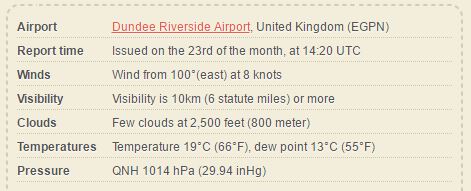
Example TAF:
EGPN 231420Z 10008KT 9999 FEW025 19/13 Q1014
There is a site HERE that is meant for METARS, but will convert TAFs as well